Nairobi, Kenya
On 3 September a delegation of the GLTN Secretariat paid a visit to Mashimoni, one of the 13 settlements in Mathare, Nairobi. Mathare is a slum, housing over 500,000 residents, located some 3 km from Nairobi’s central business district between two main highways.
We meet Paul Masese and Joseph Arthur, Chairman and Vice Chairman of “Muungano wa Wanavijiji”, a community-based initiative of slum dwellers, established to set up saving schemes for the Mashimoni community. A decade ago, Muungano established links with the Pamoja Trust, a Kenyan NGO that works with Kenyan communities to address the challenges of forced eviction and to secure tenure and livelihoods of poor communities.
“During the colonial times”, explains Joseph, “Mathare used to be a stone quarry managed by an Indian businessman. When several sites of the quarry were closed down, squatters started settling there. Mathare has experienced several evictions and demolitions ever since. After the quarries were exhausted, the area was taken up by the Department of Defence who used it as a training site. The first squatters started settling there in the early 1980s.”
Mashimoni consists of some 4,500 structures, housing approximately 20,000 people. In 2011, discussion to regularize the settlement had begun, and the Pamoja Trust was subsequently tasked by the local authorities to conduct an inventory of all the beneficiaries. The community initiated a participatory enumeration exercise, using the Social Tenure Domain Model (STDM). The principal aim of this initiative was to document the settlement and share the data with the Nairobi County authorities, as well with as the original owner of the land, the Department of Defence, so that the discussion to regularize the settlement could begin.
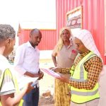
Joseph (standing in the middle) explaining the use of STDM in Mashimoni. Photo: Arno Haegens, UN-Habitat/GLTN
“Data on the settlement have been produced on paper since 2008”, explains Joseph. “However, these data accumulated large amounts of paper that were difficult to file and sometimes even got lost by the authorities. STDM enabled us to compact all data on one single CD for presentation to the county and central government authorities.”
Paul explains that, in addition, STDM has provided other great benefits, such as a more accurate definition of tenure and serving as a helpful tool in resolving disputes over property.
STDM has also helped in resettling community members, where fire outbreaks have destroyed property, amicably.
It has furthermore helped to identify the real owners of property during land transactions and avoided multiple transactions on a piece of land.
It has facilitated securing women/widows’ rights to land, where initially they would be evicted due to the lack of documents on property and has eased the management of data that includes keeping photographs of residents as opposed to manual filing methods.
“The data has also been used to document land tenure claim letters addressed to the local and national government” and enhanced the training in the STDM application in 12 other settlements by now”, Paul adds.
After an STDM demonstration, we are taken for a brief tour through the settlement and, upon departure, thank our hosts for this very informative morning.


