

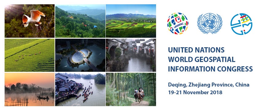
The United Nations Statistics Division (UNSD), as the Secretariat for the Committee of Experts on Global Geospatial Information Management (UN-GGIM), in collaboration with the Government of China, through the Ministry of Natural Resources and the Zhejiang Provincial Government, will be hosting the United Nations World Geospatial Information Congress (UNWGIC) in Deqing, Zhejiang Province, China from 19-21 November 2018.
The convening of the UNWGIC arises out of the mandate from the United Nations Economic and Social Council (ECOSOC) to the Committee of Experts to convene global forums to promote comprehensive dialogue on global geospatial information management with all relevant governments, non-governmental organizations and the private sector.
With an overarching theme “The Geospatial Way to a Better World” the UNWGIC will be a truly global event bringing together all stakeholders at the highest level to address and ensure that geospatial information has its widest and fullest utility in service of social, economic and environmental development. The aim of the Congress is to provide a convening, participatory and inclusive environment to enhance the communication, understanding, knowledge and application of geospatial information management to address local, regional and global challenges.
The UNWGIC will feature a high-level Opening Session, a Ministerial Dialogue and 4 Plenary Sessions dedicated to:
- Attaining Sustainable Development;
- Sharing the Digital Economy;
- Building Smart Societies; and
- Growing International Cooperation.
Through 7 dedicated thematic parallel sessions, the UNWGIC will then discuss:
- Measuring and Monitoring the SDGs;
- Digital Economy, Location Analytics and Big Data;
- Smart, Resilient and Sustainable Societies;
- Growing Global Geospatial Capability and Capacity;
- Geospatial Innovation, Science and Technology;
- Digital Silk Road and International Partnerships; and
- Sustainable Development in Action.
Through 3 special sessions, the UNWGIC will showcase:
- Measuring Deqing’s Progress Towards the SDGs with Geo-Statistical Information;
- The UN-GGIM/ World Bank Integrated Geospatial Information Framework; and a
- Young Professionals Summit convened by young professionals.
The UNWGIC will reflect the importance of geospatial information to support technological development, address the development and strengthening of geospatial information management systems and capacities, and demonstrate the importance of international coordination and cooperation for building a human data and geography community, against the three pillars of sustainable development, for a shared future and a better world, in which all are able to be counted within an inclusive global society.
More Information