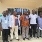
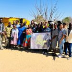
 Seventeen surveyors drawn from 15 East and Southern Africa countries were oriented in the use and application of the Social Tenure Domain Model (STDM) during a one-day training held at the Regional Centre of Mapping of Resources for Development (RCMRD) on 09 July 2013, Nairobi.
The capacity building initiative organized by the International Institute for Geo-Information Science and Earth Observation (University of Twente), Netherlands’ Cadastre, Land Registry and Mapping Agency (Kadaster) as well as RCMRD was part of a larger, ongoing training which seeks to highlight innovations in land administration.
The participants deliberated on Africa’s most persistent land challenges with a view to appreciate how GLTN and STDM attempt to solve some of the issues. Further, the land officials were acquainted with the current priorities for further development including applications for other contexts like customary and post crisis situations.
Previously, there had been no formal way of using textual descriptions as a definition of spatial units or structure. “I am excited to know that STDM offers such flexibility depending on the context of its application,” reports Mr. Godfrey Letlole, Principal Surveyor at the Department of Surveys and Mapping, Botswana.
The training ended with a hands-on training on the main features of the current version of the STDM tool, which has been customized for use in the context of a participatory enumeration and settlement upgrading.


