
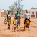


GLTN recently visited the Mwea Irrigation Scheme (MIS) to further explore the application of the Social Tenure Domain Model (STDM) tool in the management of their land records. Located in Kirinyaga County, Kenya, MIS is the largest rice irrigation scheme in Kenya, and is managed by the National Irrigation Board (NIB). It was developed on gazetted public land with an area of 30,350 acres; out of this, a total of 16,000 acres was developed for paddy production through approximately 7,500 farmers. MIS has a surface irrigation design that is fed with two river systems: Thiba and Mwea which are part of the Tana River Catchment.
The farmers, who were settled as tenants as early as 1957, were each allocated a holding of at least 4 acres and issued with a corresponding license of occupancy. However through the years, the holdings have been subdivided among family members and in other cases, transferred to new farmers. Information on license owner, successor and transfer correspondence, as well as survey plans showing the paddy fields are still in paper-based form and as result, as the Scheme Manager Mr. Innocent Ariemba noted, “STDM will provide an excellent platform for managing these records through its inherent capabilities of linking textual and spatial data, as well as document management in a centralized repository, which can be accessed by multiple users”.
As a way forward, GLTN made a commitment to MIS to provide technical services in supporting the migration of file records and survey plans from the existing paper-based records into STDM. This initiative will also act as further training on the application of STDM for staff and communities in the IFAD supported Upper Tana Natural Resources Management Programme. A detailed proposal and implementation plan will be finalized and presented.
The mission was carried out by GLTN and University of Twente (Netherlands) through a joint research on Pro-Poor Land Recordation Systems.