


The main areas of GLTN engagement on land management and planning are:
- Land Readjustment
- Citywide Slum Upgrading
- Land Use Planning
- Citywide Planning
The fundamental tenet of land readjustment is voluntary land contributions from not all but the majority of participants in a land readjustment scheme.
The readjustment of land parcels into a more systematic development with infrastructure and service provision, and the sometimes the accompanying rezoning of use or permitting of greater intensity of use, give rise to increased land value. This makes the land that remains with the land owners more valuable – an inherent incentive that motivates them to voluntarily surrender a portion of their land and participate in land readjustment schemes.
In recognition of its potential to rationalize land re-parcellation and use in and around cities of developing countries, land readjustment is one of the key tools that the Global Land Tool Network identified for further research and innovation. UN-Habitat also realized the value this tool adds in managing contemporary urbanization and has, over the years, engaged in a range of knowledge management, research and capacity development activities. These have culminated in the Global Pilot called Participatory and Inclusive Land Readjustment (PILaR) under the Achieving Sustainable Urban Development (ASUD) programme. The knowledge and expertise from this process has been distilled into a source book that enables the PILaR thinking and practice to spread and take root, particularly in parts of the world that continue to witness unprecedented rates of urbanization.
PILaR borrows from conventional land readjustment and is a mechanism through which land units that have different owners and claimants are combined into a single area through a participatory and inclusive process for unified planning, re-parcelling and development.
The development usually includes serviced urban land delivery made possible by the provision of infrastructure, public space and other urban amenities at a reasonable standard. PILaR relies on negotiated processes that allow local authorities and stakeholders to articulate their interests, exercise their formal and socially legitimate rights, meet their obligations, and mediate their differences.
In the context of PILaR, participation engages not only landowners, but also other stakeholders such as tenants and informal occupiers, who need to be sufficiently consulted and involved in the decision-making process. Their views and interests are taken into account while winning their trust, support, acceptance and ownership of the process. The expectation is that this process is participatory and hence leads to outcomes that are inclusive.
Key Documents
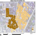
Ongoing work is targeted at systematically documenting the use of this method of urbanization in a guide. This will lead to the development of a training kit and testing programmers in informal settlements that have not yet seen significant improvements. The guide is mainly for national and local government officials, policy makers at city level, representatives of slum dwellers, community architects, NGOs, the academia and civil society organizations involved in the prevention and improvement of slums worldwide.
Key documents:
- First talk on Slum Improvement using Land Readjustment ‘LR-Slums’ : Roadmap (Coming soon)
Though land-use planning and tenure security are equally important and interlinked issues, very often they are addressed separately in planning and development practices. One reason for this might be the very specific dynamics of land tenure issues.
To address this gap, a Tenure Responsive Land-Use Planning guide has been developed to provide practical knowledge on how to improve tenure security through land-use planning, with a particular focus on applications in developing countries. The guide is based on an in-depth review of publications on land-use planning and land tenure security and builds on expert deliberations held through multi-stakeholder expert group meetings and knowledge and experiences gained from country specific case studies reflecting tenure security in land-use planning from Asia, South America, and sub-Saharan Africa. This guide is complemented by an e-learning package that supports the efficient didactic coordination of knowledge, effective learning and knowledge dissemination.
This work was a joint endeavour with the Chair of Land Management at Technische Universität München (TUM), the Sector Project Land Policy and Land Management of the Deutsche Gesellschaft für Internationale Zusammenarbeit (GIZ) and UN-Habitat through GLTN.
Key documents
Citywide strategic planning underpins a more holistic, inclusive, integrated and participatory planning approach. It takes the whole city into consideration, prioritizing good local governance, gender equity and a pro-poor focus.
It is a planning approach that supports the sustainable development of cities and metropolitan areas without concentrating solely on urban areas. It includes the surrounding vicinity and considers the needs of the peri-urban areas and their relationship with the urban areas through a participatory design and implementation process.
GLTN guidelines on citywide planning are on how to initiate a process which would result in a comprehensive strategic plan. These guidelines are generic, meaning that they accommodate deviations that may have to be made to fit the actual situation.