


 If you were to do a search for the Nairobi city slum of Mathare on Google Maps, you’d find little more than gray spaces between unmarked roads.
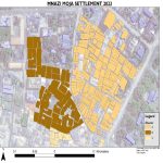
Slums by nature are unplanned, primordial cities, the opposite of well-ordered city grids. Squatters rights rule, and woe to the visitor who ventures in without permission. But last year, a group of activist cartographers called the Spatial Collective started walking around Mathare typing landmarks into hand-held GPS devices.
In a slum with no addresses and no street names, they are creating a map of what it’s like to live here.
Their map includes things like informal schools, storefront churches and day care centers, but also dark corners with no streetlights, illegal dumping grounds and broken manholes. They bring the most urgent problems to the attention of the authorities.
Slum mapper Isaac Mutisya, whom everyone calls Kaka, says they have actually been able to get a few streetlights built. And it’s always the map that makes the difference.
“Because it’s technology, it can shame some of the people,” he says. “Like, ‘Why didn’t you put up a light there when we told you that this area is dangerous?’ “
We think of GPS maps as guides. They are the sometimes annoying, always calm, recorded voice in our car that steers us through unfamiliar places. But maps are also public records that can help slum dwellers negotiate with city authorities.
Click here for the full story